Monsoon arrives early over Bay of Bengal and Andaman & Nicobar Archipelago
Monsoon arrives early over Bay of Bengal and Andaman & Nicobar Archipelago
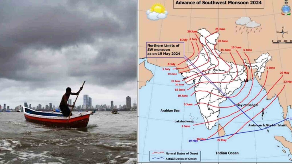
The South West Monsoon (SWM) arrived in the Bay of Bengal on May 19, 2024, three days ahead of its typical onset date of May 22, according to the India Meteorological Department (IMD). This early arrival signifies the commencement of the monsoon season over the south Bay of Bengal, south Andaman Sea, and the Andaman and Nicobar Islands.
Early Arrival and Forecast
The IMD had earlier predicted the onset of the SWM over Kerala to occur on May 31, a day earlier than the usual date of June 1. The onset of the monsoon is determined by various parameters such as the increase in westerly winds, prevalence of southwesterly winds, increased cloudiness, and continuous rainfall over the region.

The IMD has forecast above-normal rainfall for the SWM season, attributing it to several climatic factors including the expected La Nina phenomenon in the equatorial Pacific Ocean, positive Indian Ocean Dipole conditions, and reduced snow cover over the northern hemisphere in recent months. The seasonal rainfall is expected to be 106 percent of the long period average (LPA) of 870 mm. There is a 30 percent chance of receiving excess rainfall and only a 10 percent chance of below-normal rainfall.

Regional Rainfall Distribution
While most regions are expected to receive good rainfall, some eastern parts of India and most of the Northeast may receive less. The monsoon winds might encounter a low-pressure area forming in the Bay of Bengal, potentially intensifying into a cyclone. However, rapid northward progression of the monsoon could suppress cyclone formation.
Alerts and Weather Warnings
IMD has issued a red alert for Tamil Nadu and Kerala, predicting extremely heavy rainfall between May 19 and May 22 due to a cyclonic circulation in south interior Tamil Nadu and an extended low-pressure region from central Maharashtra to the cyclonic circulation. The agency has yet to issue an alert regarding a potential cyclone.
Climatic Factors Influencing the Monsoon
The last triple-dip La Nina phenomenon (2020-2023) led to extended monsoon seasons and significant flooding in several Indian states. La Nina, the cooler phase of the El Nino Southern Oscillation (ENSO), generally brings higher rainfall to India. The IMD anticipates neutral Indian Ocean Dipole (IOD) conditions to transition to positive IOD conditions during the latter part of the monsoon season, which typically increases rainfall over India.
Another factor influencing the monsoon is the snow cover extent in the northern hemisphere. The IMD noted that snow cover from January to March 2024 was below normal, which typically correlates with higher SWM rainfall.
Future Implications
The distribution of rainfall has been uneven in recent years, with instances of excessive short-term rainfall causing floods and flash floods, indicative of global warming and climate change. The 2024 SWM season, which accounts for 70 percent of India’s annual rainfall, remains crucial for understanding the impacts of ongoing climatic changes.
The IMD’s latest Monsoon Mission Climate Forecast System (MMCFS) and other models suggest that El Nino conditions will likely weaken to neutral ENSO conditions early in the monsoon season, with La Nina conditions expected to develop in the latter half.
As the SWM progresses, its impact on agriculture, water resources, and overall climate patterns will be closely monitored, given its critical role in India’s socio-economic fabric.