Why Pune’s Khadakwasla Dam Must Be Desilted Before The Next Climate Crisis Hits
Why Pune's Khadakwasla Dam Must Be Desilted Before The Next Climate Crisis Hits
Pune, June 20, 2026
The birth of Khadakwasla lake took place due to the severe droughts during the 19th century in East Pune that paralysed crop growth and prompted engineers to take up major irrigation works. Captain Fife RE of the British Army recommended a high level reservoir at Khadakwasla in 1863 and subsequently carried out detailed surveys and investigations. This man-made lake was therefore named after him, Lake Fife. It was renamed Khadakwasla Lake shortly after independence.
The work on one of the oldest masonry dams of India began in 1869 and was completed in 1879 at the cost of Rs. 65 lakhs ( then the equivalent of US$2 million and GB£600,000). Panshet Dam upstream, was designed to regulate the supply of water to Khadakwasla Lake, in such a manner that the huge reservoir would have more than adequate water for the people of Poona. This reservoir is the source of water for the two canals that started at Khadakwasla. The right bank canal is 112 km (70 mi) long and irrigates about 45,000 hectares (170 sq mi) of land in Pune district and the villages around Haveli, Daund, Indapur and Baramati, while the left bank canal supplied drinking water to Pune, Kirkee and its surroundings.


Built in 1879, the dam had a water holding capacity of 3.75 TMC, which was adequate for a population of one lakh at the time. Now 145 years later, due to siltation, the capacity of the dam has reduced to 1.75 TMC today. Sedimentation or gradual accumulation of soil in dams and reservoirs results in reduced storage capacity. This is gravely inadequate for a population of 50 lakhs and growing. Pune is now a Tier 1 city of India.
In reality, the Khadakwasla Dam is more than 50% silted thus reducing its capacity to store water by 50% during the peak monsoon season causing flooding in the down plains. This is also the main reason, why it fills up so fast. And in summers, it holds 50% less water thus causing a shortage and water rationing during the dry months for the residents of Pune. This is Double Trouble for the Punekar.
One of the factors which determines the Lifespan and Safety of a dam is the siltation that occurs over the years. What could have possibly prevented the flooding in the low lying areas along the river in Pune, was keeping space in the dam for flood mitigation, but the silt and sedimentation reduce the capacity of the dam. The sedimentation also builds a lot of pressure at the base of the dam thus increasing the risk to the structure of the dam.
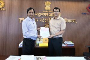
The simple solution is that the dam should be Desilted scientifically. To make it an ideal proposition for the Govt of Maharashtra, it does not have to incur any costs. In fact, our Government can earn revenue by desilting the dam.
The Maritime Research Center (MRC), along with M/s NirDhwani Technology Pvt Ltd (NDT), undertook a detailed study on the Khadakwasla lake. This unique case study in 2017 for freshwater management in urban centers was logistically supported by the National Defence Academy and partly sponsored by the Bajaj Foundation.
The MRC is a Technology Driven Think Tank based out of Pune for the last seven years. It has been founded by Dr (Cdr ) Arnab Das, a M Tech and PhD from IIT Delhi who has served in the Indian Navy for 20 years. He has been involved in multiple high profile underwater technology development efforts, including the Sonar Classifier for India’s indigenously developed nuclear submarine, coastal security for India, preservation of freshwater dolphins in the Ganga and the Chilika Lake and many more. He is at heart a naturalist and conservationist and has been deeply influenced by the subject of Biomimetics.
The MRC is actively working with the Ministry of Earth Sciences, Ministry of External Affairs, Ministry of Defence, the Director General of Shipping, the Capacity Building Commission, Govt of India and international agencies like the International Maritime Organisation and UNESCO.
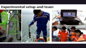
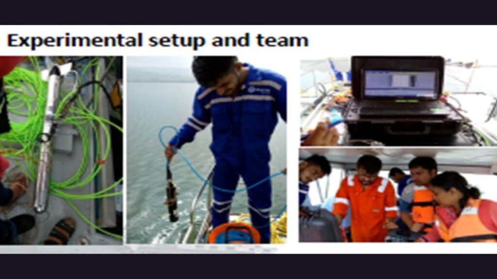
Sediment survey was undertaken using four high tech sensors, namely Side Scan Sonar, Sub-bottom Profiler, Single Beam Sonar and Conductivity, Temperature and Depth (CTD) sensor. The entire lake of 500 sq km was mapped and it was revealed that siltation is of the order of over 50% across the lake and it contains soft silt. The sediment layer is of the order of 3 to 4 meters across the lake on an average.
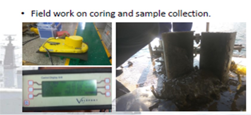
Prior to the acoustic survey, the entire lake was modelled to make sure any errors in the sonar deployment due to tropical conditions are mitigated. A PhD scholar (now a doctorate), Dr. Jyoti Sadalge, dedicated her entire doctoral research on this study. Her acoustic signal processing research contribution, ensured the accuracy of the acoustic sensor to a very high level. The modelling of the Khadakwasla lake took her more than a year and the subsequent data analysis for field experimental validation further took a few more months. Actual sediment samples were also collected using cores to validate the acoustic survey outcomes.
The inferences of the study on water resource management are as follows:
– Acoustic survey with enhanced signal processing modeling and simulation can provide critical inputs on the sediment type.
– The acoustic survey in the tropical waters faces sub-optimal performance of the sonars imported from the west, so site specific local field experimental research and development is required. The degradation of sonar performance in the tropical waters is of the order of 60% compared to the temperate/polar waters where they were designed. So the deployment of these equipment without customizing it to the local conditions is meaningless.
– The de-siltation which is the obvious next step can be better planned with these inputs. The silt can vary from hard rock to soft silt and each of the sediment type requires unique removal means, ranging from drilling and dredging for hard rock, to hydraulic suction machines to suck out the soft silt. The cost of de-siltation will vary based on the sediment type and the difference can be of the order of 10 times.
– The removal of silt is a bigger challenge for a lake of 500 sq km area and given the 3 to 4 m silt. It cannot be used for farming as suggested by many, given the size of our fragmented farms and also the logistics cost of transportation. Even the time window between the Rabi and Kharif crop, is hardly a month and it is not possible to de-silt a lake of this size within that time.
– Some voluntary organisations have collected silt from near shore fringe areas of the lake and have built embankments with earth moving equipment for tree plantation, distributed silt to farmers and undertaken tree plantation drives in upstream areas which feed the dam to mitigate the issue of siltation.
– The soft silt can be sucked out, using hydraulic suction machines and fed to a brick making plan on the side of the lake. There are brick making plants that can give an output of close to 20,000 bricks in a day using this soft silt. The government that owns the lake can make money instead of spending money by selling these bricks.
– All the issues of sediment management can be sorted out by a simple first step of sediment survey using acoustic means.
The Khadakwasla Lake supplies freshwater for domestic consumption to the city of Pune. As of date, there is no means of ascertaining the water quality in real time. It is understood that water samples are manually collected and tested at some frequency not known to the author. In a lake of 500 sq km size, even if we collect water samples manually from one end (convenient to the collector), the contamination can happen from any other side and cause a serious water quality disaster.
Advanced countries like Singapore use robots to monitor water quality in real-time across the entire storage facility and provide inputs to the consumer through mobile apps. A sensor suite mounted on a Swan Shaped robot is used to provide real-time inputs on the entire water quality with 28 parameters being monitored. Multiple such Swans can be deployed to give a detailed appreciation of the water quality across the lake. Long term analysis of such digital data can also provide nuanced inputs for policy interventions along with tactical inputs on the operational management. A consumer is constantly aware of the water quality through these low-cost gadgets. Freshwater for domestic, agricultural and industrial usage is managed effectively through such tools.
This is a simple case study that signifies, how digital transformation driven by the Underwater Domain Awareness (UDA) framework, can democratize the freshwater management in India, and Pune like it always has, can lead the way.
In developing countries, sometimes the marginalized communities are on the receiving end of such water crisis and get deprived of even basic requirement like clean freshwater. Water is getting dearer by the day and we need to address this urgently. Calibrating the water quality and then provide it to the user based on the quality requirement will allow effective and efficient management of the precious resource. The digital transformation could be cost intensive, if attempted by the individual stakeholder in isolation, however pooling of resources and synergizing of efforts can make it viable. The UDA framework as proposed by MRC & NDT ensures, policy & technology intervention along with acoustic capacity & capability building.
Our political masters in Maharashtra should avoid arbitrary, ad-hoc solutions and initiate a proper exercise to once and for all resolve the flooding and scarcity issues. Thus, saving the people of Pune a lot of grief, suffering and discomfort caused by dislocations, electrocutions and deaths during the monsoons and also the forced water shortages during the summer months which cause great anxieties in the peak of summer about availability and the arrival of the next rainy season. This exercise can also later be replicated at Pavana Lake which provides water to the Pimpri Chinchwad Municipal Corporation and is part of the Pune Metropolitan Region.
Addressing this issue of Desilting on a war footing is imperative in view of climate change and the frequently occurring extreme rain events. This will help Pune become more climate change resilient and future ready.
– Praful Talera, Advisor, Blue Economy, Maritime Research Center, Pune