Former employee explains how Google Maps solved street name problem
Former employee explains how Google Maps solved street name problem
Elizabeth Laraki, who served as the Google Maps UX Design Lead from 2007 to 2009, recently shared an interesting account on X about how Google Maps overcame the street name challenge in India, establishing itself as a leading force in the country.
As stated in Laraki’s LinkedIn profile, she led the global design team for Google Maps, overseeing activities in the United States, Australia, Switzerland, China, and India.
Her responsibilities included integrating map views for local results, reviews, driving directions, transit options, walking routes, and more.

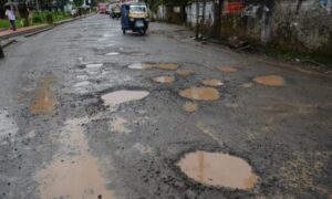
Although Google Maps was introduced in India in 2008, the company quickly encountered a unique obstacle specific to the country. According to Laraki, street names were crucial for Google Maps, but they posed a significant hurdle in India.
Laraki explains that Google Maps directions became ineffective in India due to the absence of street names, the presence of multiple names for streets, and the lack of recognition for official names.
Instead of assuming that their existing navigation system would suffice in India, Google Maps conducted on-the-ground research to understand how people in the country used landmarks for navigation.
Through this research, they discovered that landmarks were used for orientation, turn descriptions, path confirmation, and error correction.
As a result, Google Maps incorporated landmarks such as parks, monuments, shopping centers, landmark buildings, and petrol pumps to assist users in confirming their direction and rectifying errors. These changes ultimately contributed to Google Maps becoming the dominant navigation product in India.