Living on the Edge: Inside Dukuh Stabelan, Indonesia’s Closest Village to Mount Merapi’s Crater
Living on the Edge: Inside Dukuh Stabelan, Indonesia's Closest Village to Mount Merapi's Crater
Remote Central Java settlement offers unparalleled volcanic views just 3 kilometers from active peak, attracting adventurous travelers to one of the world’s most dangerous landscapes
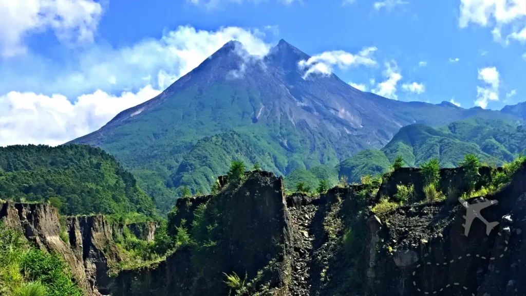
Nestled on the steep slopes of Central Java’s most volatile volcano, Dukuh Stabelan represents one of Indonesia’s most extraordinary inhabited settlements. This sub-village within Tlogolele Village, Selo District, Boyolali Regency, holds the distinction of being the closest permanent community to Mount Merapi’s active crater, positioned approximately 3 to 3.5 kilometers from the volcanic summit.
The proximity that defines Dukuh Stabelan’s identity also determines its classification as a high-risk zone for volcanic eruptions. Mount Merapi, whose name translates to “Mountain of Fire,” ranks among the world’s most active volcanoes, with regular eruptions threatening communities across its flanks. Despite persistent dangers, residents have maintained their presence here for generations, sustained by the area’s exceptional fertility and breathtaking natural beauty.
Volcanic Geography and Panoramic Splendor

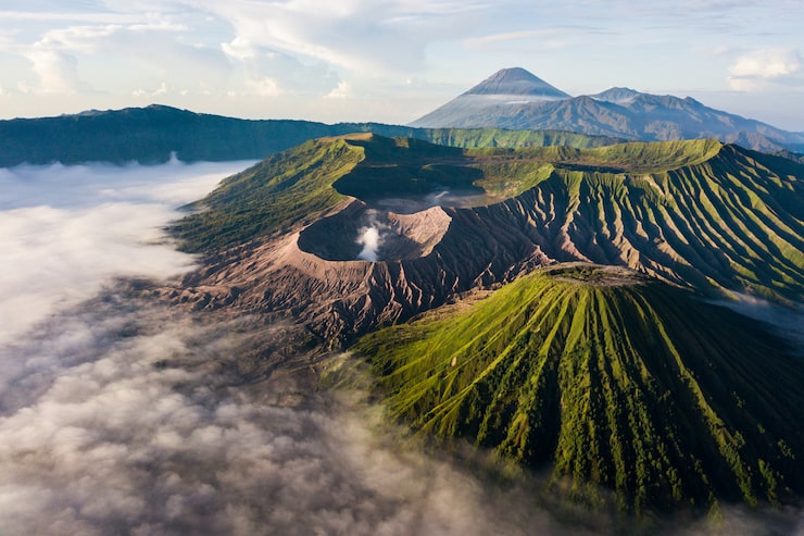
Dukuh Stabelan’s elevated position provides direct, unobstructed views of Mount Merapi’s smoking crater alongside panoramic vistas encompassing neighboring peaks including Mount Merbabu, Mount Sumbing, and Mount Sindoro. This concentration of volcanic massifs creates one of Central Java’s most dramatic landscapes, particularly striking during clear morning hours when mist clears to reveal the full mountain range.
The settlement’s location between the Apu and Glinsing rivers contributes to the region’s remarkable agricultural productivity. Volcanic ash deposits enriching the soil have transformed these slopes into highly fertile farming zones, enabling cultivation despite the inherent risks. This geological blessing and curse defines life in Merapi’s shadow, where productivity and peril coexist in delicate balance.
Colonial Heritage and Agricultural Traditions
Historical accounts suggest Dukuh Stabelan originated as a coffee plantation during Indonesia’s colonial period, when European administrators recognized the volcanic soil’s exceptional suitability for cash crop cultivation. The plantation heritage established settlement patterns that persist today, with agricultural activity remaining central to local livelihoods.
Contemporary farming extends beyond coffee to include vegetables, corn, and other crops thriving in the mineral-rich volcanic substrate. The rivers flanking the settlement provide essential irrigation, creating microclimates that support diverse agricultural production throughout the year.
Emerging Tourism Destination
In recent years, Dukuh Stabelan has attracted growing numbers of photographers, nature enthusiasts, and adventurous travelers seeking perspectives unavailable in more accessible locations. Clear weather conditions reveal landscapes of extraordinary beauty, with volcanic peaks rising dramatically above agricultural terraces that cascade down steep mountainsides.
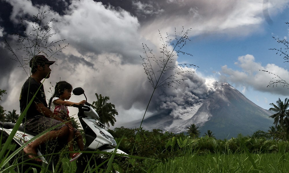
The settlement’s extreme proximity to an active crater adds an element of controlled danger that appeals to travelers seeking experiences beyond conventional tourism circuits. Visitors can witness volcanic activity firsthand, observing steam plumes rising from Merapi’s summit while standing in inhabited communities that maintain normal daily routines despite persistent threats.
Access and Practical Considerations
Reaching Dukuh Stabelan requires traveling through Selo District, itself positioned at high elevation between Mount Merapi and Mount Merbabu. The journey involves navigating steep, winding roads that may become challenging during rainy periods or following volcanic activity that deposits ash across the region.
Travelers should monitor volcanic alert levels before visiting, as authorities regularly adjust risk assessments based on seismic activity, gas emissions, and crater observations. Access restrictions may be implemented during periods of heightened volcanic activity, prioritizing visitor safety over tourism access.
The settlement offers limited tourist infrastructure, reflecting its character as a working agricultural community rather than a developed tourism destination. Visitors seeking overnight accommodation typically base themselves in Selo or nearby towns, making day trips to Dukuh Stabelan for photography and landscape observation.
Best Visiting Conditions
Optimal visiting periods occur during Indonesia’s dry season, typically May through September, when clear skies maximize visibility and road conditions remain favorable. Early morning hours provide the clearest atmospheric conditions before afternoon clouds typically obscure mountain peaks.
Photographers particularly value the golden hour lighting that illuminates volcanic peaks during sunrise, creating dramatic contrasts between illuminated summits and shadowed valleys. The interplay of light, volcanic landscapes, and agricultural terraces produces compositions unavailable in less topographically dramatic regions.
Cultural and Geological Significance
Beyond its visual appeal, Dukuh Stabelan represents broader themes in Indonesian society: the complex relationship between communities and volatile natural forces, the economic calculus balancing risk against agricultural productivity, and cultural traditions emphasizing resilience in hazardous environments.
The settlement embodies questions facing volcanic communities worldwide: how close is too close, what constitutes acceptable risk, and how traditional practices adapt to modern scientific understanding of volcanic hazards. These tensions play out daily in communities like Dukuh Stabelan, where generational knowledge and contemporary monitoring systems both inform decision-making.
Key Facts about Stabelan
Location: Stabelan is the highest hamlet in Tlogolele Village, Selo District, Boyolali Regency.
Proximity: Situated only 3-5 kilometers from the summit, making it extremely vulnerable to pyroclastic flows (hot gas clouds) and ash rain.
Survival Strategy: While some neighboring areas have been wiped out, Stabelan often experiences severe ash rain, as seen in the 2010 eruption. Residents often refuse to evacuate permanently, prioritizing the care of their cattle and farms.
Economic Drivers: The area is known for coffee plantations, which thrive in the fertile, volcanic soil, providing a crucial, albeit high-risk, income source.
Culture: The volcano is deeply revered in local tradition, viewed as the “heart of creation” and a source of both destruction and fertility.
Despite the constant threat of volcanic activity, residents in Stabelan maintain a daily routine, navigating between evacuation orders and their traditional way of life in the “red zone”.
For travelers, visiting this remote settlement offers perspective on human adaptation to extreme environments and the compelling forces that keep communities rooted in dangerous landscapes despite recurring catastrophes. The experience transcends conventional sightseeing, providing insight into how geography shapes culture, economy, and daily existence in one of Earth’s most volcanically active regions.
Dukuh Stabelan remains simultaneously beautiful and precarious, offering travelers willing to venture beyond standard itineraries an encounter with landscapes shaped by fire, communities sustained by volcanic fertility, and vistas few will ever witness firsthand.